Do it the right way
The drone industry has evolved remarkably in the past few years, with a vast number of companies emerging from this exciting revolution. To make things even more attractive, civil aviation authorities from several countries (including Australia) are opting for less restrictive rules when it comes down to flying sub-2Kg aircraft not above 400 feet.
We support this move as a necessary stage of the maturity process that the RPAS industry is undergoing. It will ultimately strengthen the drone services market, as only the most experienced, safety-oriented and reliable operators will make their way through to the top. However, we are very concerned about unprofessional services being delivered in the interim, blurring the benefits that the RPAS industry can offer.
We were recently approached by a client who had engaged with an operator with little experience with complex operations. He was really disappointed with the results obtained for a project with the following requirements:
- Survey 3.7Km of water canals, to map the embankments between -0.6m and 1.6m (MSL);
- Lay and measure ground control points in the area, to ensure high accuracy
- Data collection on low tides was a strong requirement, as it was necessary to maximise the exposure of the formed banks;
- Conduct safe and compliant flights over a densely populated neighbourhood;
- Generate a Digital Terrain Model (DTM) of the area, removing all built structures over water and connected to the banks, such as jetties and pontoons, and all stationary watercraft;
- Generate a high-definition orthomosaic of area.
Obviously, a challenging project. After all, there are 160 pontoons in that area. Yet, it is totally achievable if the right software, techniques and skills are employed.
We happened to have access to part of the deliverables previously sent to the client, and the results speak for themselves:

In a project requiring proper engineering rigor, delivering a DTM in which vegetation is still influencing surface modelling is definitely not a good sign.
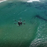
Scout Aerial engaged to conduct all new flight operations and imagery processing steps. Not even the ground control point marks laid by the former operator could be reused, as they were too small for proper imagery georeferencing. The image below shows some GCP measurement locations (white crosses). You can probably see one straight away (laid by Scout Aerial surveyors). Now try to find the other ones laid by the former operator:

Interested to see the difference? See below some samples of our work:


Do you have a similar problem? Contact us now and have it solved the right way.