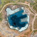
Our bathymetric surveys measure depths and map features underwater.

Traditional bathymetric surveys require labour-intensive and time-consuming practices using manned vessels equipped with sophisticated equipment. Surveyors face challenges involving safety and accessibility, especially in shallow waters and where hazardous material or obstructions exist.

Using purpose-built remotely operated watercraft equipped with state-of-the-art sensors, we gather reliable and insightful data to assist with monitoring or construction designs while minimising the safety risks of sending personnel out onto the water. Easy to launch and manoeuvre around obstructions, our vessels can be deployed in small or constricted water bodies where a manned vessel would be impossible to operate.

The advanced dual-frequency sonar system mounted to our bathymetric vessel sends out an array of soundwaves that bounce off the water body floor and back to the sensor. The return signals provide a measurement of the water depths which allow us to map a three-dimensional model of the surface underwater.

We also operate underwater ROVs (Remotely Operated Vehicles) to conduct high-resolution visual observations of features or assets underwater. Capturing detailed still images and video footage empowers engineers to make decisions regarding the condition of critical assets with reduced risk of exposing inspection personnel to extended periods of time in underwater confined spaces.

Our fast and accurate results with high positional accuracy support increased productivity and efficiency in a variety of applications.

Useful for:

  • Underwater digital terrain models
  • Contours of creeks, streams, rivers, dams
  • Profiles & cross-section data of water bodies
  • Volumetric analysis of water bodies
  • Fill and removal analysis for dam construction
  • Data to support environmental monitoring
  • Tailings Dam monitoring for compliance
  • Change detection due to tides and currents
  • High-resolution imagery to support inspection & monitoring of underwater assets (bridge footings, dam walls, pipelines etc.)

Key Benefits

Powerful Insights

Pit Digital Terrain Model

bathy_model_depths

Dam Digital Terrain Model

bathy_model_dam

Canal Digital Terrain Model

bathy_overlay

Coating blistering

Surface breakdown

Sediment

bathy_sediment

Surface condition

Floor debris

Surface breakdown

Use Cases

Bathymetric Surveys

Using advanced sonar sensors mounted to remotely piloted boats, we can measure the depth of a water body and map its underwater features.

Contact us today to discuss your requirements.